"How do I get to Broadway? ...I want to get to the center of things"
"Walk east a block and turn down Broadway and you'll find the center of things if you walk far enough."
Jon Dos Passos, Manhattan Transfer
The continuity of the gridiron gave rise to an open urban frontier that, by definition, extended infinitely. Before 1950, the urban gridiron flowed seamlessly into the continental grid, creating a continuum for which there was no interior and exterior.
Albert Pope, Zone Research, (via http://blog.nickaxel.net/)
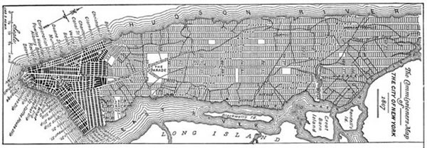
In Delirious New York, Rem Koolhaas describes the origins of the strict gridiron street pattern of Manhattan, as commissioned in 1807 by Simeon de Witt, Gouverner Morris and John Rutherford. Even though the island was barely inhabited, the grid inscribed upon the island created thousands of city blocks, the future of the city defined and delimited.
"The Grid is, above all, a conceptual speculation. In spite of its apparent neutrality, it implies an intellectual program for the island: in its indifference to topography, to what exists, it claims the superiority of mental construction over reality.
The plotting of its streets and blocks announces that the subjugation, if not obliteration, of nature is its true ambition.
All blocks are the same; their equivalence invalidates, all at once, all the systems of articulation and differentiation that have guided the design of traditional cities. The Grid makes the history of architecture and all lessons of urbanism irrelevant. It forces Manhattan's builders to develop a new system of formal values, to invent strategies for the distinction of one block from another.
The Grid's two-dimensional discipline also creates undreamt of freedom for three-dimensional anarchy. The grid defines a balance between control and de-control in which the city can be at the same time ordered and fluid, a metropolis of rigid chaos."
Koolhaas describes Manhattanization as a process, an irresistible force of artifice conquering nature.
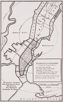
Manhattan Extended
In 1922, long after the grid had been filled, the famed engineer T Kennard Thomson proposed extending Manhattan island to the south, with a land reclamation project that would add 'Six square miles of New Land' and '12 Lineal Miles for New Wharves. Kennard's proposal was a cut down version of his earlier 1916 plan for a Really Greater New York which planned over 50 square miles of additional land. The plan included filling in the existing East River and building a New East River channel to cut through Long Island.
Extend NY
The conceptual project ExtendNY by Harold Cooper goes even further, extending the Manhattan street grid around the world.
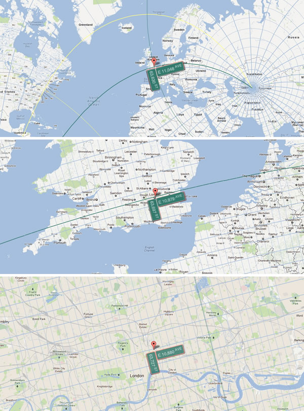
Mapping a rectilinear grid onto a sphere is not a straightforward exercise, but the result is a Google Maps overlay that allows you to see on what NY 'street' you live. (I live on the corner of 63, 696 Street and East 10794 Avenue)
Like Bud Korpenning's futile search for the heartbeat of a city in Manhattan Transfer, the city becomes ever more unknowable, less well defined, fuzzier, it extends everywhere. Everywhere is simultaneously center and periphery.
We are all New Yorkers now.