The fractal dimension of the Gulf coast is increasing.
Inspired by the recent pamphlet, The Gulf by Rem Koolhaas and AMO, my current obsession is looking at the Persian Gulf coastline on Google Earth. The publication, based on the research presented at the recent Venice Biennale, (as mentioned in this previous post), seeks to analyse the remarkable development occurring along the Gulf coast:
"A coastal analysis reveals a new regional and global order of effort, conceptualization, and rivalry that needs to be acknowledged and investigate".
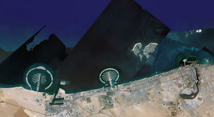
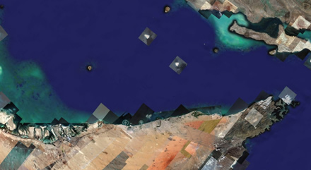
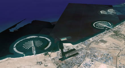
Whilst the great land reclamation projects in Dubai are the best known, such as the Palm Jumeirah, the Palm Jebel Ali and the bizarre World development, a closer look at Google Earth shows that all along the Gulf coast, man-made curlicues and geometric patterns are being created, little Julia Sets, increasing the fractal dimension of the Gulf Coast. The new Palm Deira, announced in 2004, will be larger than Paris. In total, the Palm islands will add 520km of beach to Dubai's coast.
One side of the concertina folding pamphlet is a composite satellite image of the Gulf coast from Dubai up to Kuwait, straightening out the curve of the land into a straight line. Onto this image are added images of future projects planned, proposed an hypothetical, from the emerging Palm islands of Dubai to the Pearl development in Qatar, new land reclamation projects in Kuwait City and Bahrain.
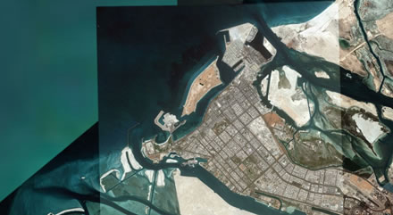
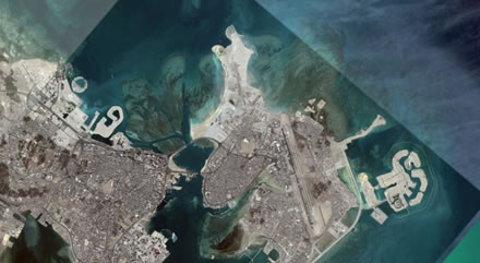
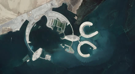
But Google Earth replaces the uniformity of the Koolhaas satellite image (from Earthsat) with a stunning, interactive Suprematist composition of form and colour. The blocks corresponding to individual images have slightly different tones according to the time of day they were imaged, and across the landmass of the Arabia peninsular we can the traces of the satellite sweeps across the terrain. The brown and yellow hues of the desert contrast with the azures and lazuli of the sea. Zoom in and the image is blurred into an Impressionist canvas, an instant Monet. Slowly detail images, an island, a coastline, and then cities, roads, the trace of man:
"Sand and sea along the Persian Gulf, like and untainted canvas, provide the final tabula rasa on which new identities can be inscribed."
Zoom in on Dubai and the Palm islands appear, zoom closer and you can see the Burj al-Arab hotel, road networks laid out for future development. All along the coastline, SimCity is being played out for real.
In the article "Dubai's Satellite Urbanism", George Katodrytis describes how the UAE's Ministry of labor are using hi-res satellite images to monitor construction.
"There is a new type of urbanism: designing islands and coastlines visible from the sky, recorded by satellites and transmitted across the Internet as jpeg attachments. Technologies that are used to monitor wildlife development, hydrography and land drought is now a tool for global transmission of projects under construction. Post-card GIS and reconnaissance technologies turn into spectacle and telegenic fantasy addressing mass tourism. Dubai’s suburbs are rising from the water, in the form of artificial and prosthetic islands, imitating Venice. Dubai is turning into a postcard portrait city of the future. Satellite imagery of unfinished projects gives rise to the exciting promise of fantasy."
But while developers and government agencies are using satellite images to design Dubai, Google Earth is also the ideal way to visit Dubai.
Dubai is the first city in the world designed to be viewed from space.
Previously